Professional Elevation Plans For Your House Or Building...
At Island Survey Systems, we provide highly accurate and detailed Elevation Plans to support architects, homeowners, planners, and developers across the Isle of Wight, Hampshire, and the South of England.
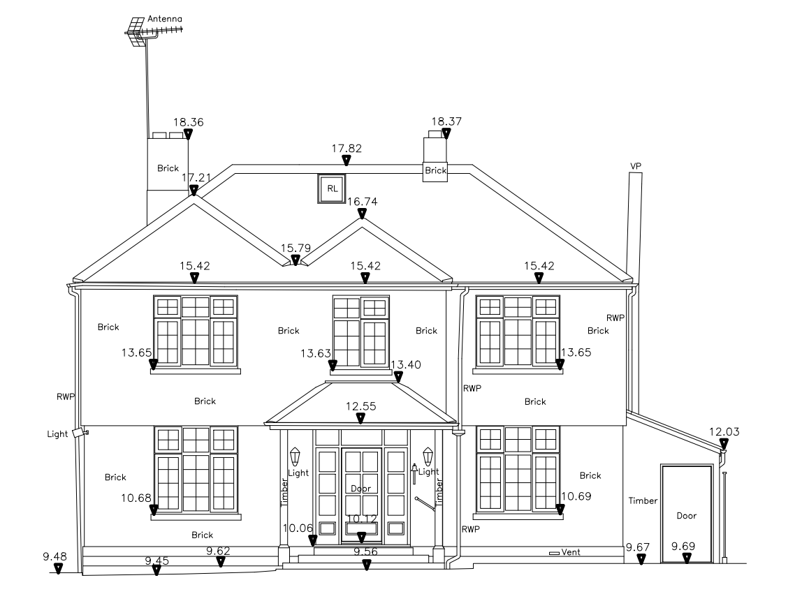
Using advanced 3D Laser Scanning technology, we produce reliable front, rear, and side elevation plans that give you a precise representation of your building or site before any design or construction work begins.
What Are Elevation Plans?
Elevation Plans are scaled drawings that show the vertical surfaces of a house or building, including all architectural details. These plans clearly display the appearance, proportions, and key structural elements of each façade, such as:
Windows and doors
Rooflines and gables
Chimneys
Structural features and decorative elements
Materials and external finishes
Elevation Plans are essential for planning applications, renovations, extensions, and new build design work, providing professionals with an accurate picture of the existing site.
Our Elevation Plan Process
After completing an on-site 3D Laser Scan, our surveyors convert the scan data into precise building elevation plans. These drawings offer exceptional clarity and accuracy, ensuring architects and designers can work from dependable measurements.
The detailed information we provide supports faster decision-making, reduces design errors, and helps streamline planning stages — ultimately improving project efficiency and delivery timelines.
Why Choose Island Survey Systems For Elevation Plans?
- High-accuracy Elevation Plans created from precise 3D Laser Scanning.
- Clear, scaled drawings suitable for planning, design, and construction.
- Ideal for house extensions, home renovations, and full building redesigns.
- Experienced local surveyors with attention to architectural detail.
- Fast turnaround and reliable digital output formats for designers and architects.
- Expertise across the Isle of Wight, Hampshire, and the South of England.
Our goal is to provide the clear and accurate elevation information you need to confidently progress your project.
Download A Sample Elevation Survey
If you’d like to see the quality and clarity of our work, you can download an example here: Download Sample Elevation Survey
Get A Quote For Your Elevation Plans
If you’re planning a new project and need accurate Elevation Plans for your house, building, or site, Contact Island Survey Systems today, to discuss your requirements with one of our experienced surveyors.